

STING COPPER PROJECT
PROJECT
OVERVIEW
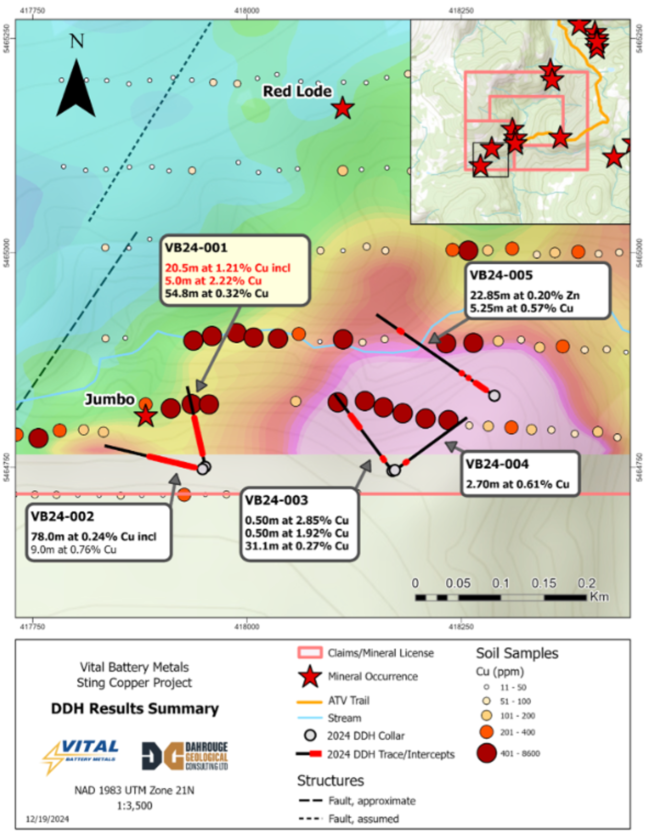
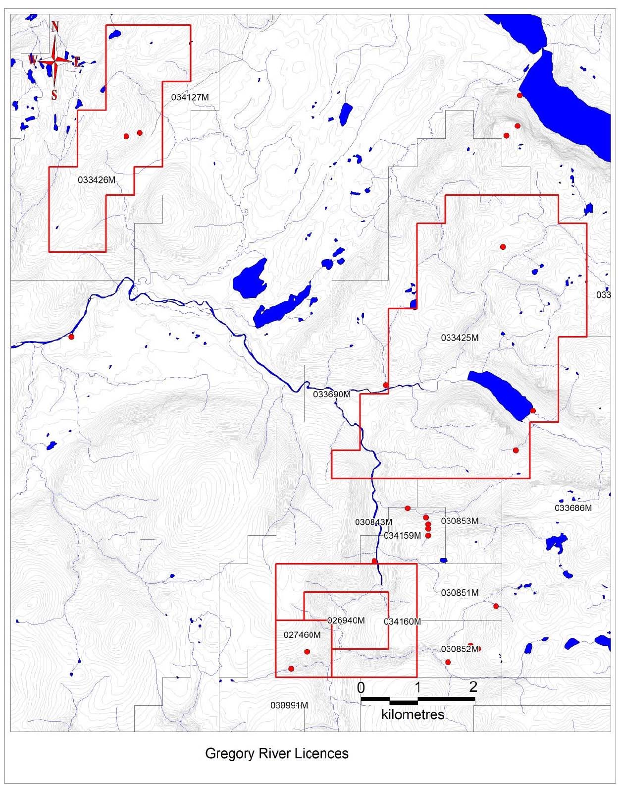
The project comprises 5 mineral claims, covering an area of 36.6 km², located about 35 km northeast of York Harbour Metals Inc. (market cap ~$80M).
Mineral Occurrences: Over 10 government-documented mineral occurrences are present on the property.
Channel samples assayed 14% Cu over 3.0 m and 9.3% Cu over 10.0 m. Grab samples assayed 6.4% Cu from the basal 0.3 m of lode and 0.13% Cu from the upper 1.5 m of the lode. Dean (1978) estimated grade and tonnage of high-grade ore as 14.7% Cu and 13,400 tonnes and disseminated ore as 6.0% Cu and 25,000 tonnes.
Noranda (1991) confirmed the mineralized zone and identified anomalous copper in soil. Grab sample results reported by Noranda showed values ranging from 0.12% to 2.5% Cu, 0.23% to 1.87% Pb, 0.38% to 8.93% Zn, 4.9 g/t to 59 g/t Ag, and 53 ppb to 780 ppb Au.
Significant Copper Deposit — The Jumbo occurrence includes channel samples of 14% Cu over 3 meters and 9.3% Cu over 10 meters, with grab samples showing 6.4% Cu from the basal 0.3 m and 0.13% Cu from the upper 1.5 m.
STING COPPER PROJECT
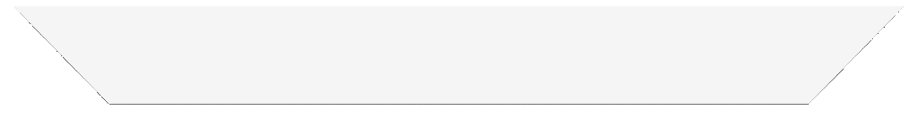
2024 DRILLING PROGRAM
Initial drilling at the Sting Copper Project, previously reported as 9.0% Cu across 9.1m (Assessment File 012G/08/0002).
Key results include:
- VB24-001: Intersected 54.8m at 0.32% Cu starting at a depth of 27.0m, with higher-grade intervals including six samples (≥0.5m length) ranging from 0.96% to 5.43% Cu. The main mineralized zone, likely extending from the Jumbo showing, begins at 81.8m, yielding 20.5m at 1.21% Cu, with chalcopyrite-rich zones up to 7.12% Cu over 0.5m.
- VB24-002: Drilled westward under the Jumbo showing, intersecting broad,
lower-grade mineralization with 78.0m at 0.24% Cu, including 9.0m at 0.76% Cu.
The maiden drill program delivered strong copper results;
- VB24-001: 20.5m at 1.21% Cu including 5.0m at 2.22% Cu and 54.8m at 0.32% Cu*
- VB24-002: 78.0m at 0.24% Cu including 9.0m at 0.76% Cu
- VB24-003: 0.50m at 2.85% Cu and 0.50m at 1.92% Cu and 31.1m at 0.27% Cu
- VB24-004: 2.70m at 0.61% Cu
- VB24-005: 22.85m at 0.20% Zn including 3.5m at 0.51% Zn and 0.50m at 1.24% Cu and 0.60% Zn and 1.05m at 1.13% Cu and 0.12% Zn and 5.25m at 0.57% Cu
STING COPPER PROJECT
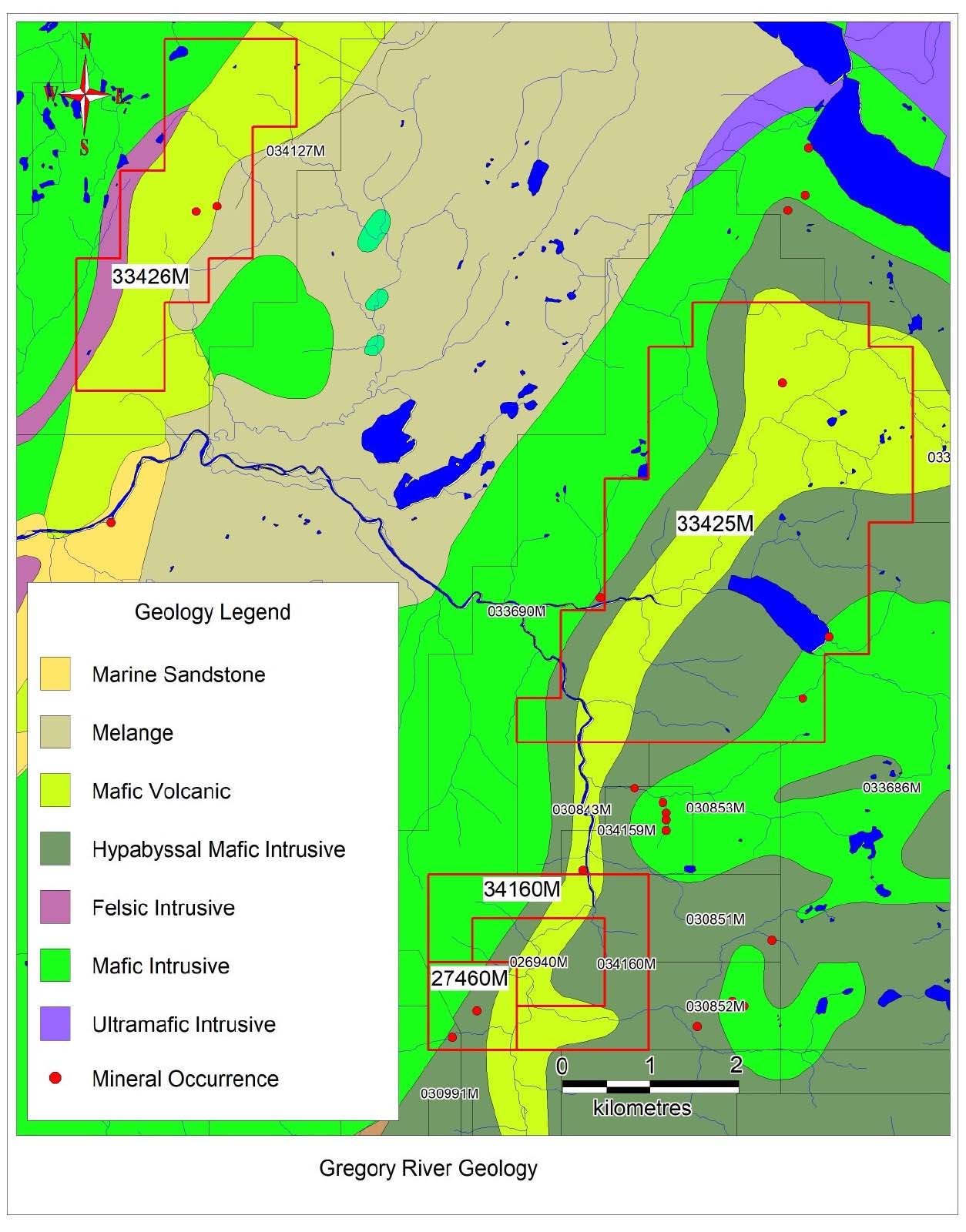
GEOLOGY
ZONE 1: JUMBO DEPOSIT
-
The Jumbo Lode is situated along the south bank of Jumbo Brook, 14 km south of the settlement of Trout River. Access is available via muskeg trail from Trout River or by helicopter from Deer Lake.
-
The occurrence is hosted within gabbroic and/or mafic dykes of the Bay of Islands ophiolite complex, where copper mineralization occurs as either massive or disseminated.
-
The ore is localized near the Gregory River Fault, forming a highly sheared contact between the gabbro and basic volcanics. Newfoundland government data indicates 17 drill holes and trenching on the adjacent Mitch Copper Prospects.

STING COPPER PROJECT
previous work
Channel samples have shown assays of 14% Cu over 3.0 m and 9.3% Cu over 10.0 m. Grab samples revealed 6.4% Cu from the basal 0.3 m of the lode and 0.13% Cu from the upper 1.5 m. Dean (1978) estimated the grade and tonnage of high-grade ore at 14.7% Cu and 13,400 tonnes, with disseminated ore at 6.0% Cu and 25,000 tonnes.
1922
The Jumbo Lode was first trenched and sampled in 1922 by Reid Nfld. Co. Ltd., and Cape Copper Mines conducted additional trenching and dug two adits between 1953 and 1954.
1970
In 1970, Noranda conducted mapping, soil sampling, and Mag, S.P., and JEM (shoot-back) surveys. The following year, Derry, Michener, and Booth performed additional sampling throughout the area.
1979-1980
In 1979-80, minimal sampling was carried out by several companies, including Chevron Minerals, Teck Corporation, RioCan, Placer Development, Utah Mines Ltd., and Noranda Exploration Co. Ltd.
STING COPPER PROJECT
ADDITIONAL ZONES
ZONE 2: RED LODE DEPOSIT
- The occurrence is located on a tributary just north of Jumbo Brook, where copper mineralization is hosted within light to dark green, medium- to coarse-grained gabbro of the Lower Ordovician Bay of Islands ophiolite complex.
- Extensive work has been reported on adjacent copper occurrences.
- Norseman Corp. Ltd. optioned the properties from Mines and Forests Nfld. Ltd. in 1929, recommending tunnels be driven in the Hall, Palmer, #6, #7, Mitchell, and #9 lodes. Prior to 1939, two adits were driven on the Jumbo Lode. Between 1951 and 1954, Cape Copper Mines Ltd. drilled 17 holes totaling 1,490 meters on the Mitchell Lode. In 1953-54, the Newfoundland Government drilled the Court A and B holes. Although copper was intersected, no assays were recorded in the drill logs.
STING COPPER PROJECT
ADDITIONAL ZONES
ZONE 3: LODE #9 PROSPECT
The sulphide-bearing vein, which outcrops on the west bank of the Gregory River near the intrusive contact between gabbros and metavolcanic rocks, occupies a brecciated zone where the country rocks are largely cemented by quartz.
Assay results for channel samples reported by Hatch (1922) include: 1.63% Cu over 0.3 m, 1.88% Cu over 0.6 m, 6.17% Cu over 1.37 m, 1.07% Cu over 0.7 m, and 11.4% Cu over 0.68 m.
VIEW CORVO
URANIUM PROJECT